
Knowing what weather is coming can mean the difference between having a full harvest or no harvest at all. Advances in early warning and forecasting systems can make the difference. From satellites and drones to crowdsourced data from people on the ground, technology can enable climate information to reach those who need it when they need it.
Innovation examples
-


 3. Agriculture and forestry / Early warning systems, modelling and monitoring / Innovation examples
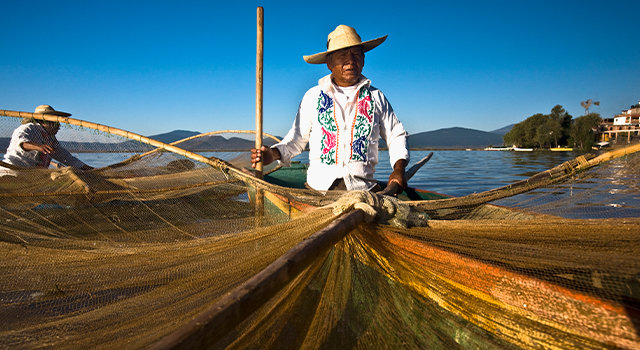
Early warning system for locust swarms
Getty Images /© Jennifer WatsonAbove average rainy seasons create favorable conditions for locust swarms to breed. A small swarm of 1 km² can in just one day consume crops and vegetation that could feed 35,000 people[1]. Their invasion presents a huge threat to food security in Africa and the Middle East. In 2020, it was estimated that the desert locust outbreak in Ethiopia put over 1 million Ethiopians in need of food assistance (World Bank, 2020b). The FAO, which is leading global work on desert locust control, was instrumental in reducing the negative impact on lives and livelihoods. The Organization quickly delivered desert locust surveillance and control to the three most affected countries of Ethiopia, Kenya and Somalia. The FAO Desert Locust Information Service (DLIS) early warning system applies a range of different technologies to the daily monitoring of conditions that favor locust invasions.[2] The system draws on locust data shared by 20 countries and field teams via the eLocust3 tablet for data collection. The information is analyzed together with satellite imagery and weather and habitat data. This enables forecast-based alerts to be issued up to six weeks in advance of a possible invasion. To make data collection more accessible in the field, the FAO and University of Pennsylvania have developed a mobile smartphone app. Together with global GPS supplier Garmin, they also modified a satellite data communicator to enable farmers without connectivity to collect data. Locust data is sent to the FAO and then shared with teams on the ground and in the air who can quickly target and eradicate swarms using chemical pesticides and biopesticides[3].
-
 3. Agriculture and forestry / Early warning systems, modelling and monitoring / Innovation examples
Mapping soils to maximize food production
Getty Images /© dem10In Sub-Saharan Africa, 30 percent of people are facing food insecurity, partly as a consequence of an underperforming agriculture sector.[1] Lack of knowledge about soil conditions has long been one of the limiting factors for managing soil fertility and achieving higher yields. In 2009, the International Soil Reference and Information Centre (ISRIC) began the first digital soil mapping of Africa, covering 42 Sub-Saharan countries.[2] The initiative, named the Africa Soil Information Service (AfSIS), combined satellite data with soil measurements taken on the ground to provide updated information on soil texture and moisture and nutrient levels in support of farmers and policymakers across the continent. Maps were made publicly available for any farmer to use when taking decisions on what type and amount of fertilizer to apply to their land to maximize food production. Advances in satellite imagery are now enabling more high-resolution and accurate assessments and predictions. While the most current information can often be obtained via a country’s national soil services, organizations such as the FAO have compiled and harmonized such information in regional datasets, or used the data to develop digital soil maps. Consistent sets of indicators and field protocols to assess soil and land health such as the Land Degradation Surveillance Framework (LDSF) can also become part of monitoring frameworks.[3]
Proven technologies
-

 3. Agriculture and forestry / Early warning systems, modelling and monitoring / Proven technologies
Crop monitoring and irrigation control using satellite information
Satellogic
Getty Images /© Nicolo SertorioSatellogic specializes in satellites that monitor the status of particular geographical areas in real time. The company has its own satellites and is capable of providing services that optimize production processes through the analysis of satellite imagery. Services available are crop monitoring, irrigation control, tree counting, estimation of biophysical variables, production control and classification of land use, among others.
- Contracting type: Service
- Technology level: High
- Country of origin: United States
- Availability: Worldwide
-
 3. Agriculture and forestry / Early warning systems, modelling and monitoring / Proven technologies
Crop monitoring using artificial intelligence, machine learning and machine vision
Austral Falcon Sensing Solutions
Getty Images /©Thomas BarwickAustral Falcon Sensing Solutions is a precision agriculture company that provides monitoring and prediction of agricultural variables. The platform uses vehicle-based machine vision, artificial intelligence and machine learning technology to capture data and digitize processes normally carried out manually in the agricultural industry. This enables faster decision-making based on quantitative information about factors such as yield, irrigation and fertilization. Data can be entered into an app which then processes the relevant data to provide crop maps, harvest estimations and so on.
- Contracting type: Service
- Technology level: High
- Country of origin: Chile
- Availability: Worldwide
-

 3. Agriculture and forestry / Early warning systems, modelling and monitoring / Proven technologies
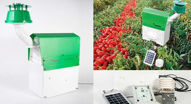
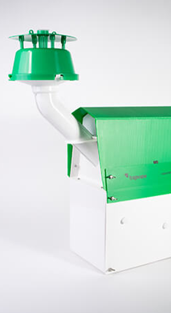
Wireless sensor networks for management of agricultural resources
Envira IOT
Photo:© Envira IOTNanoenvi® AG is a device designed for remote data capture and transmission in precision agricultural applications. The device allows the creation of wireless sensor networks to monitor, predict and optimize the management of agricultural resources in real time due to their cloud connection. These networks give greater control to farms, enabling them to manage disease, regulate the application of plant protection products, make efficient use of water in irrigation and optimize resource use in general. Nanoenvi® AG is compatible with various types of sensors, such as meteorological (temperature, humidity, pressure, rain, solar radiation), gas (H2S, CO, CO2, SO2) or agricultural (leaf moisture, soil pH, dendrometers and so on). Through solar-powered wireless sensors connected to the cloud, the farm knows the real-time status of a wide range of variables involved in agriculture. By connecting to the service through computer, mobile phone or tablet, a farmer can take immediate crop productivity decisions.
- Contracting type: For sale
- Technology level: High
- Country of origin: Chile
- Availability: Worldwide
-

 3. Agriculture and forestry / Early warning systems, modelling and monitoring / Proven technologies
Crop yield prediction using satellite and geospatial data
S4Risk
Getty Images /© Igor BorisenkoS4Risk is a platform that generates insights into agricultural production through geospatial databases and satellite imagery. The technology enables farmers to take better investment decisions by calculating climate change-related risks to crops, for example from drought and floods, based on historical yields and guide them in buying appropriate insurance.
- Contracting type: Service
- Technology level: High
- Country of origin: Argentina
- Availability: Argentina, Uruguay, Brazil
-
 3. Agriculture and forestry / Early warning systems, modelling and monitoring / Proven technologies
Crop monitoring and planning using sensors, drones and satellite imagery
Sentera
Getty Images /© NolanBerg11Sentera provides digital agronomic tools that give farmers access to real-time data about crop performance in the field. The software (FieldAgent) integrates weather data with data collected from the field. Data is collected through various channels, including satellite imagery, sensors and drones which fly over fields and provide an acre-by-acre crop overview. Data can then be analyzed to forecast yields and to plan and understand the impact of various fertilization and irrigation choices in maximizing yields.
- Contracting type: For sale
- Technology level: High
- Country of origin: United States
- Availability: Worldwide
-
 3. Agriculture and forestry / Early warning systems, modelling and monitoring / Proven technologies
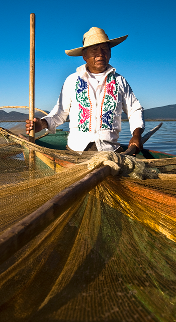
Meteorological monitoring for the fisheries sector
Clima Pesca
Getty Images /© Glow ImagesClima Pesca is an initiative of the Central American Organization of the Fisheries and Aquaculture Sector (OSPESCA) highlighting the impact of climate change on the fisheries sector. The app forecasts cyclones up to two days in advance, as well as sea surface temperature, atmospheric pressure, wind waves, marine currents and so on. Due to its user-centric design and an application that integrates relevant weather information in an easy and simple way, Clima Pesca is able to help 120,000 subsistence fishing-dependent households annually. Platform users include local and national governments, academia and civil society.
- Contracting type: Free
- Technology level: High
- Country of origin: United States
- Availability: Latin America
Frontier technologies
-
 3. Agriculture and forestry / Early warning systems, modelling and monitoring / Frontier technologies
Automated insect monitoring
EFOS/Trapview
Photo:© TrapviewThe digital tools provided by Trapview help monitor more than 60 insect species in over 40 countries around the world. The product consists of a “smart” insect trap with cameras. It is fully automated and solar powered. It provides a clear view of the various pest populations and daily sends automatic farm updates. This enables farmers to plan more accurate pest control measures and save time by not having to patrol fields and manually monitor pests.
- Contracting type: Service
- Technology level: High
- Country of origin: United States
- Availability: Worldwide
-

 3. Agriculture and forestry / Early warning systems, modelling and monitoring / Frontier technologies
Blockchain climate risk crop insurance
Sprout
Getty Images /© TU ISSprout is a startup that is leading the development of a Blockchain-based climate-risk crop insurance. The company uses satellite data and machine learning to assess climate risk. They then send mobile messages directly to farmers to advise them on unexpected weather patterns and useful advice on how to navigate the changes on their farms. Insurance companies can then offer climate insurance to farmers using Sprout’s online web portal, where insurance and program data can be monitored. Sprout insurance contracts are made using Blockchain technology. This means the contracts are automated and protected from unauthorized changes throughout the season. Sprout was developed in Kenya but is active in multiple supply chains and crops around the world.
- Contracting type: Service
- Technology level: High
- Country of origin: United States
- Availability: Kenya (pilot)
Horizon technologies
-

 3. Agriculture and forestry / Early warning systems, modelling and monitoring / Horizon technologies
“Smartdust” for detailed crop and environmental monitoring
Analog Devices Inc.
Getty Images /© Shutter2UMicromechanical systems (MEMS), or “smartdust,” are a network of wireless devices, or “motes,” with sensors that can collect, process, store and transmit data[1]. These swarms of microscopic computers can range from 1 mm in size down to 0.02 mm and are best classified as a part of the industrial internet of things (IIoT). Each small device contains a microprocessors and sensor to monitor variables like pressure, humidity and crop status, and signal them back to users such as farmers. The devices are connected and communicate through a so-called mesh network. This consists of many of these small devices, with communication either by optical or radio frequency. Use cases include monitoring vast areas of crops to determine irrigation, fertilization and pest management needs. Analog Devices in collaboration with scientists from the University of California in Berkeley have also used the technology to measure snow depth, solar radiation, humidity and soil moisture on the snow pack in the Sierra Nevada Mountains. Such information can be used to anticipate droughts and floods, as well as support water resources planning. Note: Mainstream adoption is at least a decade away, high costs (due to need for satellite tech etc.) and there are potential privacy and security concerns (potential for surveillance and military use).
- Contracting type: Service
- Technology level: High
- Country of origin: United States
- Availability: N/A
REDD stands for “Reducing Emissions from Deforestation and forest Degradation”. The “+” represents forest conservation and management.
Hydroponics is using water as a medium instead of soil, whereas aeroponics is growing plants suspended in misted air. Aquaponics combines hydroponics and fish farming in an integrated nutrient recycling system.
FAO (2021c). The state of food and agriculture 2021. Food and Agriculture Organization of the United Nations (FAO). Available at: https://www.fao.org/3/CB4476EN/online/CB4476EN.html [accessed August 2022].
Allen, C.D., D.D. Breshears, and N.G. McDowell (2015). On underestimation of global vulnerability to tree mortality and forest die-off from hotter drought in the Anthropocene. Ecosphere, 6(8), 1-55.
Ibrahim, A., R.C. Abaidoo, D. Fatondji and A. Opoku (2016). Fertilizer micro-dosing increases crop yield in the Sahelian low input cropping system: A success with a shadow. Soil Science and Plant Nutrition, 62(3), 277–88.
Sebnie, W., M. Mengesha, G. Girmay, T. Feyisa, B. Asgedom, G. Beza and D. Dejene (2020). Evaluation of micro-dosing fertilizer application on sorghum (Sorghum bicholor L) production at Wag-Lasta Areas of Amhara Region, Ethiopia. Scientific Reports, 10(1), 6889.
McKinsey (2022). Precision forestry: A revolution in the woods. McKinsey. Available at: https://www.mckinsey.com/industries/paper-forest-products-and-packaging/our-insights/precision-forestry-a-revolution-in-the-woods [accessed October 2022].
FAO and FILAC (2021). Forest governance by indigenous and tribal people. an opportunity for climate action in Latin America and the Caribbean. United Nations Food and Agriculture Organization (FAO) and Fund for the Development of Indigenous Peoples of Latin America and the Caribbean (FILAC). Santiago, Chile: FAO. Available at: https://www.fao.org/documents/card/en/c/cb2930en/
World Bank (2021a). Opportunity assessment to strengthen collective land tenure rights in FCPF countries. Social inclusion in climate finance. Washington, DC: World Bank. Available at: https://openknowledge.worldbank.org/handle/10986/36499.
Gerster-Bentaya, M. (2013). Nutrition-sensitive urban agriculture. Food Security, 5, 723-37.
Beacham, A.M., L.H. Vickers, and J.M. Monaghan (2019). Vertical farming: a summary of approaches to growing skywards. The Journal of Horticultural Science and Biotechnology, 94(3), 277-283.
Agrawala, S., C. Bordier, V. Schreitter and V. Karplus (2012). Adaptation and innovation: An analysis of crop biotechnology patent data. OECD Environment Working Papers, Paris: OECD. Available at: www.oecd-ilibrary.org/environment/adaptation-and-innovation_5k9csvvntt8p-en
Nishimoto, R. (2019). Global trends in the crop protection industry. Journal of Pesticide Science, 44(3), 141-147.
Shoham, J. (2020). The rise of biological products in the crop protection and plant nutrition markets. IHS Markit. Available at: https://ihsmarkit.com/research-analysis/the-rise-of-biological-products-in-crop-protection-and-nutriti.html [accessed October 2022].
Azis, F., M. Rijal, H. Suhaimi and P.E. Abas (2022). Patent landscape of composting technology: A review. Inventions, 7 (2) Available at: www.mdpi.com/2411-5134/7/2/38.
UNEP (2021). Adaptation Gap Report 2021: The gathering storm. Nairobi: United Nationals Environment Programme. available: https://www.unep.org/resources/adaptation-gap-report-2021
Heinrich Böll Foundation (2021). 10 things to know about climate finance. [online] available: https://issuu.com/heinrichbollfoundationnorthamerica/docs/hbs-10things2021-book?embed_cta=embed_badge&embed_context=embed&embed_domain=climatefundsupdate.org&utm_medium=referral&utm_source=climatefundsupdate.org [accessed October 2022].
GCF (2022). Annual results report. Green Climate Fund (GCF). Available at: https://www.greenclimate.fund/sites/default/files/document/20220412-arr2021.pdf
Metinko, C. (2022). Why VC investors are plowing record sums into agtech. Crunchbasenews. Available at: https://news.crunchbase.com/startups/agtech-startups-vc-funding-data/.
GCA (2021). Green bonds for climate resilience: A guide for issuers. Global Center on Adaptation (GCA). Available at: https://gca.org/wp-content/uploads/2021/11/A-guide-for-issuers-Full-report-online.pdf
FAO (2015). Climate change and food security: risks and responses. Rome: Food and Agriculture Organization of the United Nations (FAO). Available at: https://www.fao.org/3/i5188e/I5188E.pdf
Singh, A. (2021). Soil salinity: A global threat to sustainable development. Soil Use and Management, 38.
IPCC (2022). Working Group II Sixth Assessment Report. Impacts, adaptation and vulnerability. Summary for policymakers. Geneva: Intergovernmental Panel on Climate Change. available: https://www.ipcc.ch/working-group/wg2/
Wiebe, K., H. Lotze-Campen, R. Sands, A. Tabeau, D. van der Mensbrugghe, A. Bieweld, B. Bodirsky, S. Islam, A. Kavallari and D. Mason-D’Croz (2015). Climate change impacts on agriculture in 2050 under a range of plausible socioeconomic and emissions scenarios. Environmental Research Letters, 10(8).
Climate-ADAPT (2019). Use of adapted crops and varieties. The European Climate Adaptation Platform Climate-ADAPT. [online] available: https://climate-adapt.eea.europa.eu/en/metadata/adaptation-options/use-of-adapted-crops-and-varieties [accessed October 2022]
González Guzmán, M., F. Cellini, V. Fotopoulos, R. Balestrini and V. Arbona (2022). New approaches to improve crop tolerance to biotic and abiotic stresses. Physiologia Plantarum, 174(1).
Cleantech Group (2021). Genetic engineering for crops and food: climate adaptation, resilience, and food security through innovation. Available at: https://www.cleantech.com/genetic-engineering-for-crops-and-food-climate-adaptation-resilience-and-food-security-through-innovation/ [accessed October 2022].
FAO (2022a). Genetically modified crops: Safety, benefits, risks and global status. Food and Agriculture Organization of the United Nations (FAO). Available at: https://www.fao.org/policy-support/tools-and-publications/resources-details/en/c/1477336/ [accessed July 2022].
NAS (2016). Genetically engineered crops: Experiences and prospects. Washington DC: National Academies of Sciences, Engineering, and Medicine (NAS). Available at: https://www.cleantech.com/genetic-engineering-for-crops-and-food-climate-adaptation-resilience-and-food-security-through-innovation/
IPCC (2019). IPCC special report on the ocean and cryosphere in a changing climate. Summary for policymakers. Geneva: IPCC, WMO, UNEP. Available at: https://www.ipcc.ch/srocc/download-report/
ALM (2021). Organic fertilizers market- opportunities and forecast 2021-2030. Allied Market Research. Available at: https://www.alliedmarketresearch.com/organic-fertilizers-market-A14536 [accessed October 2022].
CGIAR (2021). Innovation: Fertilizer microdosing. Consultative Group on International Agricultural Research (CGIAR). Available at: https://www.cgiar.org/innovations/fertilizer-microdosing/ [accessed October 2022].
USDA (2022). Virtual Fencing. A climate adaptation strategy. United States Department of Agriculture. Available at: https://www.climatehubs.usda.gov/hubs/northwest/topic/virtual-fencing-climate-adaptation-strategy [accessed October 2022].
MarketsandMarkets (2021). Hydroponics market report. Available at: https://www.marketsandmarkets.com/Market-Reports/hydroponic-market-94055021.html#:~:text=Countries%20such%20as%20the%20Netherlands,use%20of%20climate%20control%20technologies [accessed October 2022].
Dubbeling, M. and H. de Zeeuw (2011). Urban agriculture and climate change adaptation: Ensuring food security through adaptation, Resilient cities. Proceedings of the global forum 2010. Series: Local sustainability, Springer.
WEF (2018). Innovation with a purpose: The role of technology innovation in accelerating food systems transformation. Geneva: World Economic Forum. Available at: https://www3.weforum.org/docs/WEF_Innovation_with_a_Purpose_VF-reduced.pdf.
Research and Markets (2022). Global water recycle and reuse technologies market 2022: Climate change and drought resilience compels adoption of water reuse. Available at: https://www.globenewswire.com/en/news-release/2022/03/18/2405982/28124/en/Global-Water-Recycle-and-Reuse-Technologies-Market-2022-Climate-Change-and-Drought-Resilience-Compels-Adoption-of-Water-Reuse.html [accessed October 2022].
Fischer, G., F. Tubiello, H. Velthuizen and D. Wiberg (2007). Climate change impacts on irrigation water requirements: Effects of mitigation, 1990–2080. Technological Forecasting and Social Change, 74, 1083–107.
Gondim, R., M.A. Castro, A. Maia, S. Evangelista and S. Fuck Jr (2012). Climate change impacts on irrigation water needs in the Jaguaribe river basin. JAWRA Journal of the American Water Resources Association, 48 (2) 355–65.
Woznicki, S., A. Nejadhashemi and M. Parsinejad (2015). Climate change and irrigation demand: Uncertainty and adaptation. Journal of Hydrology: Regional Studies, 34.
FAO (2022c). Water: Key facts. United Nations Food and Agriculture Organization (FAO). Available at: https://www.fao.org/water/en/#:~:text=FAO%20estimates%20that%20irrigated%20land,improved%20irrigation%20management%20and%20practices [accessed October 2022].
CMI (2022). MENA drip irrigation system market 2022 analysis by market trends (drivers, constraints, opportunities, threats, challenges and investment opportunities), size, share and outlook. Coherent Market Insights. Available at: https://www.digitaljournal.com/pr/mena-drip-irrigation-system-market-comprehensive-research-future-trends-industry-analysis-segments-and-competitive-landscape-jain-irrigation-systems-ltd-netafim-ltd-eurodrip-sa [accessed October 2022].
IFPRI (2010). What is the irrigation potential for Africa? International Food Policy Research Institute (IFPRI). Available at: https://www.ifpri.org/publication/what-irrigation-potential-africa
Evans, R. and E. Sadler (2008). Methods and Technologies to Improve Efficiency of Water Use. Water Resources Research, 44(7).
Kozlowski, T.T. and S.G. Pallardy (1997). 8 - Cultural practices and reproductive growth. In T.T. Kozlowski and S.G. Pallardy, eds., Growth control in woody plants, San Diego: Academic Press, 394-435.
FAO (2021d). The state of the world’s land and water resources for food and agriculture – Systems at breaking point. Synthesis report. Rome: Food and Agriculture Organization of the United Nations (FAO). Available at: www.fao.org/3/cb7654en/online/cb7654en.html [accessed October 2022]
Mekonnen, M.M. and A.Y. Hoekstra Four billion people facing severe water scarcity. Science Advances, 2(2), e1500323.
Qin, Y. and A. Horvath (2020). Use of alternative water sources in irrigation: Potential scales, costs, and environmental impacts in California. Environmental Research Communications, 2.
Velasco-Muñoz, J.F., J.A. Aznar-Sánchez, A. Batlles-delaFuente and M.D. Fidelibus (2019). Rainwater harvesting for agricultural irrigation: An analysis of global research. Water, 11(7).
Rojas-Downing, M.M., A.P. Nejadhashemi, T. Harrigan and S.A. Woznicki (2017). Climate change and livestock: Impacts, adaptation, and mitigation. Climate Risk Management, 16, 145-63.
Boone, R., R. Conant, J. Sircely, P. Thornton and M. Herrero (2018). Climate change impacts on selected global rangeland ecosystem services. Global Change Biology, 24(3), 1382–93.
FAO (2012b). Livestock and landscapes. Food and Agriculture Organization of the United Nations (FAO). Available at: https://www.fao.org/3/ar591e/ar591e.pdf [accessed October 2022].
Heinke, J., M. Lannerstad, D. Gerten, P. Havlík, M. Herrero, A. Notenbaert, H. Hoff and C. Müller (2020). Water use in global livestock production – Opportunities and constraints for increasing water productivity. Water Resources Research, 56.
CIAT (2014). Submission from the International Center for Tropical Agriculture (CIAT) on behalf of the CGIAR Research Program on Climate Change, Agriculture and Food Security (CCAFS), to UNFCCC SBSTA 42 on issues related to agriculture in response to SBSTA decision FCC/SBSTA/2014/L.14. The International Center for Tropical Agriculture. Available at: https://unfccc.int/files/documentation/submissions_from_non-party_stakeholders/application/pdf/516.pdf [accessed October 2022].
Rivera-Ferre, M.G., F. López-i-Gelats, M. Howden, P. Smith, J.F. Morton and M. Herrero (2016). Re-framing the climate change debate in the livestock sector: Mitigation and adaptation options. WIREs Climate Change, 7(6), 869–92.
Williams, T., C. Wilson, P. Wynn and D. Costa (2021). Opportunities for precision livestock management in the face of climate change: A focus on extensive systems. Animal frontiers: The review magazine of animal agriculture, 11, 63–8.
IFAD (2009). Livestock and climate change. International Fund for Agricultural Development (IFAD). Available at: https://www.uncclearn.org/wp-content/uploads/library/ifad81.pdf
IPBES (2019). The global assessment report on biodiversity and ecosystem services: A summary for policymakers. Bonn, Germany: Intergovernmental Science-Policy Platform on Biodiversity and Ecosystem Services. Available at: https://ipbes.net/sites/default/files/2020-02/ipbes_global_assessment_report_summary_for_policymakers_en.pdf
FAO (2020). Global forest resources assessment 2020. Rome: Food and Agriculture Organization of the United Nations (FAO). Available at: https://www.fao.org/documents/card/en/c/ca9825en
Sakr, G., I. Elhajj and G. Mitri (2011). Efficient forest fire occurrence prediction for developing countries using two weather parameters. Engineering Applications of Artificial Intelligence, 24(5), 888–94.
Six, D. (2019). Forest Health and Biotechnology: Possibilities and Considerations. Washington, DC: National Academies Press.
Reytar, K., D. Levin, E. Goldman, F. Stolle, M. Weisse and P. Potapov (2022). 36 countries are gaining more trees than they're losing. World Resources Institute (WRI). Available at: https://www.wri.org/insights/tracking-global-tree-cover-gain?utm_campaign=wridigest&utm_source=wridigest-2022-06-29&utm_medium=email&utm_content=learnmore [accessed October 2022].
JRC (2022). Seasonal trends for EU countries. European Commission Joint Research Centre (JRC). Available at: https://effis.jrc.ec.europa.eu/apps/effis.statistics/seasonaltrend [accessed October 2022].
UNFCCC (2022c). UN early warning systems must protect everyone within five years. United Nations Framework Convention on Climate Change (UNFCCC). Available at: https://unfccc.int/news/un-early-warning-systems-must-protect-everyone-within-five-years [accessed October 2022].
Ky-Dembélé, C., J. Bayala, D.S. Dayamba, C. Adeyemi, P. Dorward, A. Agali, A. Diakite, R.B. Zougmore and N. Lamien (2020). Taking the participatory integrated climate services for agriculture (PICSA) approach to extension actors for strengthening resilience in Africa: Five years’ experience in West Africa. CGIAR Research Program on Climate Change, Agriculture and Food Security (CCAFS). Available at: https://ccafs.cgiar.org/resources/publications/takingparticipatoryintegrated-climate-services-agriculture-picsa [accessed October 2022].
Cowan, Y., E. O’Brien, and N. Rakotomalala-Rakotondrandria (2014). Community-based early warning systems: Key practices for DRR implementers. OCHA and FAO. Available at: https://www.fao.org/publications/card/en/c/57c0a761-8d31-4f0f-8a07-27e1ea0568d5/.
Rydhmer, K., E. Bick, L. Still, A. Strand, R. Luciano, S. Helmreich, B. Beck, C. Grønne, L. Malmros, K. Poulsen, F. Elbæk, M. Brydegaard, J. Lemmich and T. Nikolajsen (2022). Automating insect monitoring using unsupervised near-infrared sensors. Scientific Reports, 12.
FAO (2021a). Climate change fans spread of pests and threatens plants and crops, new FAO study. Food and Agriculture Organization of the United Nations (FAO). Available at: https://www.fao.org/news/story/en/item/1402920/icode/#:~:text=FAO%20estimates%20that%20annually%20up,insects%20at%20least%20%2470%20billion [accessed October 2022].
Friedman, R., E. Mackenzie, R. Baiga, K. Inape, S. Crimp and M. Howden (2022). Designing climate information services to enhance resilient farming activities: Lessons from Papua New Guinea. Frontiers in Climate, 4, 871987.
World Bank (2020b). The locust crisis - The World Bank’s Response. The World Bank Group. Available at: https://www.worldbank.org/en/news/factsheet/2020/04/27/the-locust-crisis-the-world-banks-response [accessed October 2022].
CERF (2020). CERF allocation report on the use of funds and achieved results. Eastern Africa rapid response locusts response 2020. Central Emergency Response Fund. Available at: https://cerf.un.org/sites/default/files/resources/20-RR-EAF-40783_Eastern%20Africa_CERF_Report-regularpdf.pdf.
FAO (2021b). A high-tech response is helping countries win battle against Desert Locust. Food and Agriculture Organization of the United Nations (FAO). Available at: https://www.fao.org/news/story/pt/item/1397940/icode/ [accessed October 2022].
Bjornlund, V., H. Bjornlund, and A.F. Van Rooyen (2020). Why agricultural production in sub-Saharan Africa remains low compared to the rest of the world – a historical perspective. International Journal of Water Resources Development, 36(sup1), S20-S53.
Gilbert, N. (2009). Digital soil map for Africa launched. Nature News, 13 January. Available at: www. nature.com/articles/news.2009.17.
ICRAF (2020). The land degradation surveillance framework. World Agroforestry Center [International Council for Research in Agroforestry] (ICRAF). Available at: https://worldagroforestry.org/output/land-degradation-surveillance-framework [accessed October 2022].
Forbes (2018). Smart dust is coming, are you ready? Forbes. Available at: https://www.forbes.com/sites/bernardmarr/2018/09/16/smart-dust-is-coming-are-you-ready/?sh=745edf6c5e41 [accessed October 2022].